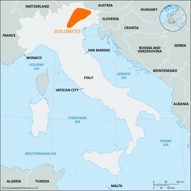
The Dolomites are well known to backpackers, skiers, and other outdoor enthusiasts from around the world. I’ve been planning to hike there for years. This was the year, with backpacking gear on hand from a recent Balkan hike with Bill Ramsey. The two hikes were relatively close to each other, and we made productive use of the time in between with some meandering in Croatia and Slovenia. There are many hikes that criss-cross the Dolomite region. We settled on the Short Alta Via 1, a four-day trek that gave a good sample of the region (Alta Via translates to “high way” in Italian).
First a little background. What are the Dolomites? A spectacular mountain range located in the Alps of Northeast Italy, they were designated a UNESCO World Heritage Site in 2009 for their exceptional natural beauty and significant geologic science value. They are named for the dolomite limestone from which they formed about 250 million years ago. During this time, the area was submerged in a warm, shallow tropical sea where coral reefs thrived. Over millions of years, these reefs and other marine sediments were compressed and solidified into the dolomite rock that makes up the mountains. Over their history, the sedimentary rock eroded in a manner leaving the light-colored jagged peaks that attract tourists from around the world. There are 18 peaks over 10,000 feet. Certainly impressive, but considerably shorter (and much older) than the European Alps.
Good visual of sedimentary layers.
The starting point for the Short Alta Via 1 was the town of Cortina d’Ampezzo. an upscale resort surrounded by mountains that stays busy with both summer and winter tourists. Events were held here for the 1956 Winter Olympics, and the town was abuzz with construction preparing for events in the upcoming 2026 Winter Olympics. We arrived in Cortina d’Ampezzo from Venice on a comfortable 3-hour bus ride. Our hike started and ended here at the Hotel Aquilla.
Hotel Aquilla
Cortina d’Amprezzo with Tofana Ski Slopes in background
I booked this trip through bookatrekking.com. They are a large outfit with hiking packages all over the world. I was happy with them. Payments were easy and I thought reasonable. The mobile app contained a lot of information, including an offline mode that allowed you to track the hike (and hike profile) using gps. I wouldn’t hesitate to use them again.
Day 1 June 19, 2025
A benefit of staying at Hotel Aquilla at the start and the end of the hike was that this allowed us to store luggage we didn’t need on the hike in a storage room for free. After checking out and storing our unnecessary luggage, we headed off to the bus stop. For this route, we caught a pair of buses to the hike start at a beautiful alpine lake called Lago di Braies. From here we would hike back to Cortina d’Amprezzo. Ticket reservations weren’t required at this time of year, but the second bus was standing room only. There were a lot of folks at the lake, but not too many were distance hikers.
Lago di Braies, our starting point. Mountain climb begins at back left.
Looking across Lago di Braies to where our mountain climb starts.
After a pleasant walk around the lake, the trail heads up into the mountains. The day hikers at the lake were soon left behind. The trail climbs over 3300 feet in the next four miles, with some steep rocky sections providing cables to help avoid slips and falls. Nearing the high point the trail becomes a rock field. The payoff when you reach Forcella Sora Forno pass is well worth the climb – a vast panorama of the mountains ahead. The pass is also where we entered the Dolomiti National Park. One of many rifugios is a short drop from the pass. This wasn’t our stop for the day, but I did take the opportunity for a hydration break.
About an hour into the climb.
The climb continues.
Trail Blaze for the hike.
Rocks. There’s always rocks.
Crossing Forcella Sora Forno pass
The trail from here was very pleasant and we made good time. Unfortunately, a mile or so of that was on the wrong trail and we had to back up. There are many trails in the area, it is very important to have a gps map of some format on this hike and refer to it often.
The trail in the distance was great. Just not ours.
The next several miles were just a wonderful stroll in beautiful territory; the stuff memories are made of. The day ended with a steep drop of 2500 feet to our lodging for the night, Rifugio Pederü. I had low expectations when we checked into our “dormitory” style room but was pleasantly surprised when we got there. Very comfortable, electric outlet and light for each bunk, lots of gear storage space, and an excellent shower.
Perfect. Just perfect.
Descending to Rifugio Pederü in the valley.
Rifugio Pederü, our stop for the night.
Rifugio Pederü bunks. Nice. Very nice.
Hike for the day per my Garmin: 10.2 miles, 3380 feet total ascent.
The second day started with another climb, though not as severe with 2100 feet of ascent in the first four miles and some level sections blended in. It’s the long continuous grinds that wear you down.
Early morning climb on day 2.
Not a care in the world.
Trails side bee hives.
The trail was smooth, and there was an increase in E bikes that went along with that. Some of the rifugios we passed even had charging stations for them. This was a much more mature trail than our recent Balkan experience, with a corresponding increase in the frequency and comfort level of accommodations. I read before the hike that toilet paper on the trail was an unfortunate side effect of the increased traffic, but I did not find that to be the case.
Sometimes not, but mostly E bikes.
Most of the day was in full sun exposure until the last couple of miles. Benches were placed at photogenic spots, making for welcome breaks to soak in the landscape. After a pleasant elevation profile for much of the day, we had a steep 500-foot climb at the end to reach our lodging for the next night at Rifugio Scotoni. This was another very comfortable lodging with plenty of refreshments available. We had dinner with new friends from Chili and Belgium.
Note the hikers on the trail to give perspective to the mountains.
How do they survive??
One of many benches with a beautiful view.
Rifugio Scotoni for second night.
Europeans love flower boxes.
Our routine for the duration of the trip was to wash our shorts, shirt, and socks in the shower or sink and hang them out to dry. Today was no different.
Hike for the day per my Garmin: 10.8 miles, 3809 feet total ascent.
Day 3 June 21, 2025
Our third day started, as always, with a long climb, this time an 1800-foot climb in about two miles. A lot of work had been done with stone and timber placement to make the section as friendly as possible, still, this was a robust start to the day. We stopped for photos at a small, alpine lake on our way to Falzarego Pass.
Breakfast at Rifugio Scotoni, typical for the hike.
Climb to start day 3. That’ll get your blood flowing.
A huge amount of effort went into making this section passable.
Pretty alpine lake just off trail.
A stunning landscape unveiled itself as we crossed the pass. This was one of the rare occasions on the trip where cloud cover impacted views, but the swirling clouds provided a distinct character of their own.
Crossing Falzarego Pass.
Love the scree fields.
More dramatic cloudscapes.
We dropped back into the valley, only to immediately climb back a 1000-foot climb to our destination for the day, Rifugio Scoiatolli. All the rifugios had bustling day traffic that thinned out to the overnight guests over the afternoon. This rifugio was especially crowded when we arrived, due to the accessibility and the spectacular scenery. Cinque Torri (“Five Towers”) is the featured attraction here, but the 360° scenery makes this as photogenic as any spot on the hike.
Sometimes it appears it is just easier to go through instead of around.
How’s that for an afternoon view?
Cinque Torri, “Five Towers”.
While the location was spectacular, and the dinner as good as any we had on the hike, the rooms did not match. The beds were comfortable and private lockers outside the room were convenient, but eight people in one small room is a bit crowded.
Main dish after first course of spaghetti with fresh tomatoes and basil. No problems here.
Accomodations a little tight at Rifugio Scoiattoli.
Hike for the day per my Garmin: 7.8 miles, 3042 feet total ascent.
Day 4 June 22, 2025
A hard rain late afternoon the previous day was the only one we experienced on the hike, but that set the stage for a beautiful morning for the last day. The feature today was the 5100-foot descent back into Cortina d’Amprezzo rather than the ascent. Still, there was over 2000 feet of climbing, 700 in one particularly nasty stretch of steep, exposed, loose rock.
Beautiful start to the day.
Looking back at Cinque Torri after a couple of hours on the trail
One last tough climb, with loose gravel as additional challenge.
After a refreshment at Rifugio Pomedes we began the last stretch of steep downhill – literally down 1700 feet of ski slope. From there we continued the rest of the way to Cortina d’Amprezzo, mostly through pleasant forests. The hike is predominantly exposed to full sun so the sections under canopy were nice.
Looking down on Cortina d”Ampezzo from Rifugio Pomedes.
Just be careful.
Pleasant end after steep section coming down ski slope.
Shot of calories at the end of the hike!
Hike for the day per my Garmin: 10.2 miles, 2047 feet total ascent.
Total for the hike: 39.0 miles, 12,278 feet of ascent.
Parting Thoughts…
The Short Alta Via 1 is not a technical hike, but experience with long distance hiking at moderate elevation will make the trip more enjoyable. Plenty of folks take day hikes from many potential starting points. Others take the full Alta Via 1 (75 miles), or some other combination of available trails. The Short Alta Via 1 is a good compromise providing a nice sample of the Dolomites with outstanding views, and enough of a workout to have a sense of accomplishment.
A Newcomer’s Hike in the Balkans – Welcome to the Accursed Mountains!
Most Americans are familiar with some of the iconic Balkan highlights such as Athens and Dubrovnik, but much of the region is something of a mystery. It was to me. So, I made note of a trail called “The Peaks of the Balkans” when I ran across it a year or two ago, and this was the year to take the next step.
As hiking trails go, the “Peaks of the Balkans Trail” is a youngster, coming into existence in 2012. The full trail covers about 119 miles and can take 7-10 days, crisscrossing the borders of Albania, Montenegro, and Kosovo in the Accursed Mountains (also known as the Albanian Alps). Portions of the trail existed as shepherd paths for centuries if not millennia; creating the trail tied these together in a manner to connect remote villages. The hike was created, in part, to help foster economic development in these remote areas. The hike also helps to promote peace and cooperation between three countries where that didn’t always exist. Variations are available; our trek covered 47 miles in five days of hiking.
Albanis. Our hike is in the north at the boundaries with Kosovo and Montenegro.The Full Peaks of the Balkans Hike. We did not hike the Kosovo portion.
Marketing hikes in an area called the Accursed Mountains (Albanian: Bjeshkët e Nëmuna) could be considered a questionable marketing practice. Where does such a name come from? There are as many legends as a person chooses to look for. The one I took a fancy to was that the devil was unleashed from hell for a day of mischief and created the jagged peaks throughout the region. The area certainly has suffered a tortured history in the recent past. The decade from 1991 to 2001 following the collapse of Yugoslavia was especially violent, with over 100,000 deaths throughout the region in conflicts collectively known as the Balkan Wars. Remnants of machine gun bunkers, military barracks, and other military structures dot the trail today. On to the hike.
The trail is available as anything ranging from a self-guided trek with each person arranging their own sleeping arrangements and meals, to guided treks with all accommodations and meals provided. I’ve planned my share of hikes – this hike I chose the guided package with all meals and accommodations included. I rarely use a guided tour, but I decided to in this case with multiple border crossings (requiring permits) and the perceived potential for language difficulties. Several vendors offer tour packages. I chose “Balkan Natural Adventure” and gave them a five-star review. Our guides Mergim (“Megi”) and Lumi (both from Kosovo) were a blessing, handling any required communications and sharing a lot of history. Megi in particular seemed to know everyone we passed. When I asked him how many times he had hiked the trail he simply said “many times”.
Day 1, June 4 – Arrival in Shkoder
After flying into the capital and largest city of Tirana, Albania (metro population 536,000) and decompressing for a couple of days, we took a three-hour bus ride to Shkoder where our adventure again. Bill Ramsey joined me from the US for this trip. In Shkoder we met the rest of our diverse group from the UK, US, Japan, and Canada. Megi and Lumi introduced themselves during our pre-hike brief. We got to know each other a little and went over what was to come in the next five days of hiking.
Afternoon In Shkoder. Those seats will fill as the sun goes down
Lumi (left) and Mergim, our guides for the week. Great guys!
Day 2, June 5 – Transfer from Shkoder to Theth by van, hike from Theth to Valbona
We checked out from the Promenade Hotel in Shkoder and loaded up into the van for a three-hour ride to the start of our hike in Theth, Albania. We enjoyed getting to know our hiking companions as we left the valley and began our ascent into the Albanian Alps, a long stretch of winding roads with hairpin turns. This was beautiful territory. The elevations aren’t extreme – the highest point on the entire hike was only about 7000 feet with surrounding peaks only around 9000 feet. That certainly doesn’t detract from their grandeur – they compare with any I’ve seen in the European Alps, Patagonia, or the American Rockies.
Off to the mountains.
Our first views of the Accursed Mountains on the van ride to Theth. Dang!
Theth is a tiny town with a permanent population of about 370 – and that was the largest village we would hike through. The creation of the hike breathed life into this once nearly deserted village. We began our hike here and it didn’t take long to get a taste of what we would see for the next five days. We climbed about 3450 feet, almost all of that in the first four miles to Valbona Pass. The Swahili term “Pole, Pole” (meaning slowly, slowly) was the theme for the week on these long uphill grinds. We passed a couple of residences as we climbed through beech forests and mountain meadows where locals took advantage of the opportunity to sell refreshments to passing hikers. These were the first of many we would pass with varying levels of service.
In Theth, preparing to start the hike.
Spring-cooled bathtub beverage cooler.
Beech forests
We stopped for a break at Valbona Pass, with a spectacular view of Maja Jazerces ahead of us. The Valbona Valley awaited us as we began our descent, the landscape shifting to a pine forest. Cool mountain streams refreshed us. Arriving at Bar and Restaurant Emanueli when we reached the valley, we chose to enjoy a beverage and opt for a local taxi to our lodging for the night rather than walking down a dry riverbed for the last few miles. Good call!! We arrived at Guest House Kol Gjoni in Valbona for the night.
Views from mountain meadow as we approach Valbona Pass.
Crossing over Valbona Pass with Maja Jazerces ahead (8838 feet)
Valbona Valley
Shady break.
Guest House Kol Gjoni
Hike for the day: 7.2 miles, 3455 feet of ascent (per my Garmin)
Day 3, June 6 – Hike from Valbona to Cerem
After a wonderful breakfast of hard-boiled eggs, fried bread, cheeses, cucumbers, tomatoes, and a refreshing forest tea (herbs collected in the forest, dried, then steeped to make tea), we were ready for another day.
Sunny breakfast at Guest House Kol Gjoni.
Forest TeaDrying herbs for forest tea.
The walk through town was pleasant, passing small farms and a few of the many small mushroom-capped military bunkers we passed this trip. A whopping 750,000 bunkers were built (14.7 per square mile!), during the rule of Albanian communist dictator Enver Hoxsa from 1944 until his death in 1985. Albania did not prosper during this time. At his death, Albania was the third poorest country in the world with an average income of a mere $15/month. A regrettable national symbol, remaining bunkers have largely been abandoned in place.
Abandoned military bunkers.
We then began another tough climb to start the day, this time 3600 feet in 4.5 miles. We climbed through forests and meadows before reaching the craggy, rock-strewn landscape of Prosllopi Pass (6689 feet). We enjoyed the wildflowers – June is prime wildflower season in the Balkans, while we ate lunch and listened to Megi share some of his personal history of the war-torn years.
Crossing a mountain meadow to Prosllopi Pass in the distance.
Getting rockier near the pass.
Lunchtime at Prosllopi Pass.First entry into Montenegro.
In the saddle of the pass there are remnants of a summer settlement (katun) used by shepherds tending their livestock during the summer. We saw several of these over the course of the hike. Some are still used, others abandoned. We were there early in the season and saw none in use during our hike.
Livestock pens with a small shelter near Prosllopi Pass.
Crossing the Prosllopi Pass, we entered Montenegro for the first time. An optimistic person might think we would have some relief on the trail after climbing to the pass, but no, there was a couple of miles of rock-picking to be had before finally arriving at a pleasant mountain meadow. We gathered for some photos as we crossed the border back into Albania.
Rock-picking our way down from the pass.
Smooth sailing here.
Crossing back into Albania with Bill Ramsey..
The last leg of the hike was a gentle drop through meadows and forest to the hamlet of Çerem, really just a collection of a few houses. Çerem was home to the wonderful Guesthouse Afrimi where we spent the night. Opened in 2022, this family-run guesthouse is a prime example of hiker money supporting development in remote areas. Facilities are simple but adequate, and the home-cooked meals have a unique charm giving a glimpse into local life that isn’t available on more established hikes in other areas. Chickens roam the yard while laundry dries on the line. The mother tends the kitchen preparing the next meal. The whole Peaks of the Balkans Trail experience excels in that regard.
Almost there!
Guesthouse Afrimi.
Comfortable accommodations at Guesthouse Afrimi.
The owners’ son didn’t speak English but seemed to enjoy participating in my video chat with my wife just the same.
Meals on this trip always had a protein, perhaps a chicken leg or a stuffed pepper, but this is not the feature of the meal. Instead, we had a wide variety of breads, fruit, vegetables, eggs, and dairy products as the highlights.
The owners wife working on our dinner in her small kitchen.
First course for dinner.Main course.
Hike for the day: 10.4 miles, 4015 feet of ascent (per my Garmin)
Day 4, June 7 – Hike from Çerem to Doberdol.
After a lovely breakfast, we packed our lunches from the leftovers and headed out for Doberdol. This day started off easier, with only about a 1300-foot climb through forests and meadows to reach our first high point for the day. Portions of the hike traverse the “Primeval Beech Forests of the Carpathians”, a UNESCO protected woodland that is also part of the Ancient Beech Forests of Germany that now stretch across 12 countries. We crisscrossed the Albanian – Montenegro border twice.
Farewell to Guesthouse Afrimi.
Trail blaze on Beech tree.
Research before the hike cautioned that Albanian water supplies could not be relied on as potable. That seems to be the case for some municipal supplies with aging infrastructure, but we reliably had mountains spring sources that were pure.
Refreshing spring water.
We stopped for lunch in the shade of trees alongside a wildflower filled meadow. This was a relaxing day after the taxing climb to start the last two days. We hiked a bit further before stopping at Balquina teahouse that had just opened for the season. The sweet lady served us our beverages while I inspected the interesting electrical system made up of solar panels, a car battery, and a small control center. They had a hodgepodge look but worked. The solar panels are a difference maker for these remote locations. The folks up here may not be wealthy, but they certainly enjoy million-dollar views from their highland perches.
A simple, satisfying lunch.
Abundant wildflowers.
Refreshments at Balquina teahouse.
This, plus solar panels, is the heart of the electrical system.
The sweet lady who served us.
The million dollar view from Balquina teahouse. The small buildings below are summer lodging for the shepherds and farmhands.
The descent into Doberdol Valley was an idyllic stroll into a verdant valley to the tiny village of Doberdol for our stay at Guest House Leonardi. The guest houses can serve more trekkers than there are residents living here. There are perhaps 100 local residents in the summer season; maybe a dozen in the winter.
Arriving at Doberdol.
Hike for the day: 10.3 miles, 3616 feet of ascent (per my Garmin).
Day 5, June 8 – Hike from Doberdol to Babino Polje.
This was to be an easy, fun day. After breakfast of fried eggs, cucumbers, tomatoes, and fried dough bread, I packed a dandy sandwich from the leftovers. We headed up the valley with the tri-corner border of Kosovo, Montenegro, and Albania just ahead. We didn’t make it that far, though, turning northwest to angle out of the valley towards Montenegro for a 1300-foot climb to the pass at the Montenegro border at about 7000 feet.
Building my lunch sandwich from available leftovers. Yum!
Leaving Doberdol. The tri-country border is at a peak on the upper right.
1300 foot climb back to the Montenegro border.
We stopped at the border for a break. I gazed out at the mountains and reflected. The Albanian Alps began forming about 65 million years ago, similar to the European Alps and the American Rocky Mountains. By comparison, the Appalachian Mountains where I was raised began forming about 480 million years ago. I certainly can’t confirm these numbers but it’s easy for me to sense the relative differences from the geography of the land.
Contemplating the world around me.
We continued our trek into Montenegro through high mountain meadows, passing the remnants of a military compound bombed in 1999 by NATO forces in response to an anti-aircraft battery found here. This was a brutal period of ethnic cleansing when Yugoslav forces sought to drive Kosovar Albanians out of the country (Montenegro was part of Yugoslavia at the time). A saying popular by those driven out at the time said “When I turn my back to you Kosovo, I leave snow behind and found winter” – there was no improvement in Albania.
Remnants of a violent past.
We dropped out of the meadows into alpine forest on our way to Hrid Lake. We had a leisurely lunch, reading, relaxing and taking a refreshing swim in the lake. Like many lakes in the area this is glacial fed, so sure to invigorate!
Dropping down into the alpine forest to Hrid Lake.
The ladies enjoy a swim.
The afternoon was an easy hike through forests and meadows with occasional farms dotting the landscape. We arrived at Hrid Ecolodge in Babino Polje. With construction still in progress this was another example of tourist money promoting development. We enjoyed comfortable new rooms and a spectacular spread for dinner. The owner Enes Dreskovic and his wife covered the table to overflowing with the fruits of their labor in the kitchen. There was no possible way to eat everything, but we made our best effort!
On to Babino Polje.
We may have been the first to stay here. Very nice!
Enes just kept bringing more.
Hike for the day: 9.4 miles, 1745 feet of ascent (per my Garmin).
Day 6, June 9 – Transfer from Babino Polje to Ropjana Valley. Hike to Theth. Transfer back to Shkoder.
June 9 started a little differently. After a lovely breakfast, we packed our lunches then settled in for an hour and a half van transfer to Ropojana Valley. This cut several miles of road walk and was part of the hike modification to make it a five-day hike.
Making my lunch sandwich with an Ajvarspread (made from slow-simmered eggplant and roasted red peppers), Suxhux slices (a local sausage), tomatoes, cucumber.
The hike thus far had been warm clear days and cool nights. This was our first day starting in cloud cover and the clouds shrouding the mountains gave a different perspective. We crossed the valley floor with a few hikers from other groups. This was one of the rare times that occurred. Megi said perhaps a hundred people take our particular version of the hike each year. I appreciate solitude on a hike.
Crossing Ropojana Valley. Note the size of the hikers for perspective on the size of the mountains.
Climbing to blue sky.
We climbed out of the valley through another beech forest to more mountain meadows. We enjoyed lunch as the clouds in the distance began to part. Our trek up the valley was through some of the rockiest terrain of the hike, with dramatic cliffs on either side. This section of the hike was a forbidden zone during the communist era, with military bunkers, barracks, and border markings remaining as a legacy.
Another bunker near the Albanian border. Note the trail on the lower right.
Perspective from inside a bunker.
The cloud-shrouded peaks of the border area provided some of the most spectacular vistas of the entire hike. We were nearing the end. We took time to soak in the grandeur of a part of the world that none of us had experienced before.
Nearing the end of a perfect hike.
Spectacular!
The last leg of our journey was a steep downhill drop of 4000 feet to Theth. After a brief stop at a guesthouse for a celebratory beverage, we hiked the last few hundred meters to a waiting van that returned us to Shkoder. We checked into our hotel for cleanup, then enjoyed our last dinner as a group. The next morning, we parted ways with a wonderful memory as the best souvenir.
Note Heather to get an idea of how steep trail is.
Farewell dinner. Thanks for the memories!
Hike for the day: 9.8 miles, 2595 feet of ascent (per my Garmin).
Total for hike: 47.1 miles, 15,426 feet of ascent.
Parting thoughts….
What makes a great hike? Scenery? Certainly. Fellowship? Weather? Peace and solitude? Wildflowers/wildlife? Expense? Challenge? All the above? Other considerations? These are all subjective. I’ve taken a few of the hikes you’ll find on lists of the “World’s Greatest Hikes” – Tour de Mont Blanc, John Muir Trail, Torres del Paine Circuit in Patagonia, West Highland Way, Kilimanjaro, a few others. This hike certainly holds a special place in my heart. The group chemistry was great, and the weather was perfect, the landscape was spectacular, the wildflowers were at peak. Whether that makes this hike first, second, third, whatever is simply irrelevant. One area that separates this hike from the others – the Guesthouse experience. Authentic local experiences are of high value to me, and increasingly more difficult to experience in a shrinking world. Another item that made this hike special – the “surprise” factor. I was simply unaware of what this area had to offer. That, along with the kindness shown to us and the personal attention given at each meal separated this from some of the other long-distance hikes.